Explore · Mae Kampong
Kew Fin Viewpoint
Mountain ridges and morning mist above Mae Kampong
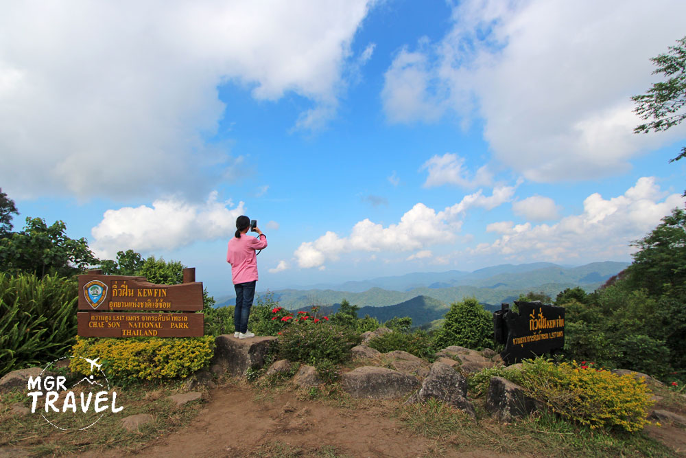
About and management · Kew Fin Viewpoint
Kew Fin Viewpoint is within Chae Son National Park. Thailand’s tourism directory identifies the 7th (Doi Lan) Ranger Station as responsible for this viewpoint. Park personnel oversee access and safety restrictions, while transport from Mae Kampong is a separate local service.
The viewpoint lies within Chae Son National Park. Village transport and guided rides are separate services; confirm their availability and conditions with operators.
Explore
Kew Fin is a ridge-top viewpoint near Mae Kampong within Chae Son National Park. It is a worthwhile nature stop when you want to look beyond the village streets.
Aim for early morning if road and weather conditions allow, but do not count on a sea of mist every day. Leave time to enjoy changing light.
Visit planning
Early morning, subject to weather and access
What to notice
A ridge viewpoint at roughly 1,517 m, with mountain panoramas but weather-dependent mist.
- Ridge panoramas and layered hills
- Seasonal variation in cloud and mist
- Steep mountain-road access
Essential information
- Location
- Chae Son National Park area, near Mae Kampong, Chiang Mai–Lampang border, Thailand
- Explore
- National-park mountain viewpoint
- Opening hours
- Access follows Chae Son National Park rules and can change in fog, storms or maintenance periods.
- Admission
- Check any park entry charges separately from village transfer or driver fees.
- Best time
- Early morning, subject to weather and access
Opening hours
Access follows Chae Son National Park rules and can change in fog, storms or maintenance periods.
Admission
Check any park entry charges separately from village transfer or driver fees.
Getting there
Take the mountain road uphill from Mae Kampong towards the park viewpoint, checking road conditions and vehicle suitability.
Open Google Maps ↗Background
Its position on the Chiang Mai–Lampang mountain ridge has made it a place to observe layered hills and the changing cloud cover of the highlands.
What to notice
The open ridge panorama contrasts with the narrow, streamside lanes and wooden houses of Mae Kampong. The horizon and successive mountain layers are the main subjects.
Core experience
Aim for early morning if road and weather conditions allow, but do not count on a sea of mist every day. Leave time to enjoy changing light.
Suggested route
- Check mountain road conditions with your host or driver in Mae Kampong
- Travel uphill in a vehicle suitable for the mountain road
- Use the designated viewpoint area, then return to the village
Before you go
The uphill road is steep and winding, and fog or rain can reduce visibility. Follow park rules and do not obstruct the road.
Photography spots
Frame several layers of hills; try both wide landscape frames and vertical compositions without leaving marked paths.
Where to stay
For an unhurried morning or evening visit, consider a village homestay and book ahead. Where to stay
Visitor reviews
Read current feedback on the individual Google Maps listing. The village rating does not represent this separate place.
Google Maps ↗Frequently asked questions
- Is there mist every morning?
- No. Cloud and mist depend on weather and cannot be guaranteed.
- Can I walk from the village?
- Check distance and the steep route first; local vehicle transfer may be more suitable.
Address and navigation
Chae Son National Park area, near Mae Kampong, Chiang Mai–Lampang border, ThailandOpen Google Maps ↗Reference: https://www.thailandtourismdirectory.go.th/en/attraction/138